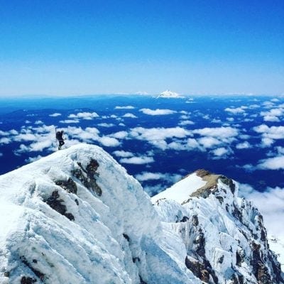
Photo Credit: Eddy van der Kloot
Part 8 – Backcountry Skiing, Snowboarding (spilt-boarding) Q&A Series
The boom in backcountry skiing, snowboarding and other snow-sports was brought on by the COVID-19 pandemic as ski resorts started closing down like falling dominoes starting in March of 2020 as state and local counties mandated ‘stay at home’ (SIP) orders as coronavirus outbreaks spiked.
Winter season 2020/21 will likely see similar trends especially pronounced if resorts are unable to implement effective protocols of limiting on-site visitors’ capacity, and social distancing especially indoors in common areas which will result in COVID infection outbreaks resulting in resorts’ closures.
Of particular concern is that finally CDC acknowledges that the coronavirus infection transmission is airborne by aerosols which means it is highly contagious. This fact does not bode well so we’ll see how this flu season and winter months play out.
Back to our topic, our backcountry Q&A feature looks at backcountry from a range of diverse perspectives, from an amateur to expert backcountry skier, from a ski shop small business retailer to backcountry touring guide, these Q&A series provide some key insights and also we’ll list resources to consider for avalanche safety training that is critical to stay safe in the backcountry. Most importantly, we list key resources to connect you with folks who share a passion and love for the backcountry.
Part 8 Q&A interview with Eddy van der Kloot, founder and creator of BackcountrySkiMaps.com
With the impact of resort closures due to the COVID pandemic from mid-March of this year, can you describe from your observations if there’s an increase in demand for backcountry skiing/boarding/snow-sports?
There’s been a definite uptick in people’s interest in the backcountry ever since COVID shut down lifts back in March, and I expect that this season will be the busiest yet for ski touring in Tahoe. Although the season has barely started, I’ve already seen an increase in demand for maps this year, which I suspect is a decent proxy for the increase in backcountry usage we’re about to see!
How did you get into creating Tahoe/Sierra topographical maps?
I’ve always been a map nerd – you don’t even want to know how many hours I’ve spent looking at CalTopo and Google Earth. After several years of backcountry skiing in Tahoe, I went up to Whistler and was pleasantly surprised to find that John Baldwin had made some incredible maps for touring in the area. That made me realize that nothing like that existed for Tahoe. There isn’t even a Tahoe-specific guidebook (though there are a few guidebooks which include some descents by the lake), much less anything that you can take out into the field. How were new ski tourers supposed to know where to go?
How many years have you been doing this and what do you find rewarding about it?
I’m in my third year of making maps now, and it’s been a rewarding process from start to finish. The whole undertaking has been a huge learning experience, which I always enjoy, but the biggest reward is when customers reach out to me and tell me how my maps have helped them have their best days in the backcountry. Ski touring has brought me so much joy, and it’s great to be able to help others get that same experience.
In terms of backcountry experience, what types of BC experience do you have? Do you go to the backcountry with a few friends or by yourself?
I don’t know how many hundreds of backcountry days I have under my belt now, but I’ve done everything from traverses to steep couloir skiing, pow days to ski mountaineering descents, and springtime corn runs to early winter bike-to-hike-to-ski days. That’s one of the joys of backcountry skiing – there are so many different ways to do it that it always keeps you interested.
I’ve done a handful of solo days, but I prefer to go out in a group of 2-4 people. I find that makes for the best combination of safety in numbers without causing too much groupthink when considering avalanche conditions.
What do you like about the backcountry?
Skiing pow without the anxiety of beating the lines at the resort certainly comes to mind first! But there’s also something enjoyable about the physical challenge of big days out. And of course getting into proper nature, away from the craziness of the resorts is a huge plus too. When I got into backcountry skiing, it was so that I could ski pow days after the resorts had been skied out, but it turns out that even the uphill is fun!
What was the most challenging part for you in creating these topo maps? How long did it take you to complete one coverage area section?
When I started the project I already had years of GPS data from my watch stored on my computer, so I thought it would be easy to just stick it on a map and go. That turned out not to be the case – there’s a ton of additional work that goes into getting things looking good, and even once the maps are printed and ready to go it takes a lot to maintain the website, find retailers, keep up with customer service, and try to give back to the community by doing things like running fundraisers with the Sierra Avalanche Center (and this winter also the Eastern Sierra Avalanche Center). It took me about 8 months of full-time work to get the first map done, but after working on my processes I can now do that in about half the time. That of course doesn’t include the years of backcountry skiing to know where all the lines are – but thankfully that’s the fun part!
Name three favorite backcountry spots you like that’s not crowded?
I’m a huge fan of Herlan Peak (on the Tahoe: Best of the Rest map), for both tree skiing during storms and steep skiing when things are stable. It doesn’t hurt that you stare straight at the lake most of the time that you’re skiing there. The area around Echo and Angora Peaks has always been a favorite of mine too – it’s stacked with little chutes and couloirs, but doesn’t see nearly as much traffic as nearby Tallac or the West Shore peaks. For my last pick I’ll go with Carson Pass – it can get busy early and late season, but there’s so much terrain down there that it’s always easy to get away from the crowds if you know where to go. There are some huge bowls back there, some fun traverses to do, and of course the Crescent Moon Couloir is one of the best around Tahoe.
Final question: what is it about your backcountry ski topo maps that stands out from other maps available on the net?
First off, I don’t think that anything as comprehensive for ski touring exists on paper or on the net. Between the three paper maps (Tahoe: North, Tahoe: Southwest and West Shore, and Tahoe: Carson Pass) and the one digital-only map (Tahoe: The Best of the Rest) there’s something like 300 ski descents, each of which includes an approach (or several different approaches) and distance and elevation gain statistics. Then there’s the self-contained guide photos and text on the back. With about 16-20 of the top descents detailed with descriptions and color photos, the maps make it easy to get into the backcountry without needing to look up additional info elsewhere.
Would you like to add anything else?
If this is your first year in the backcountry, do yourself a favor and get educated before going out. Take an avalanche course, go out with more experienced friends, and always err on the side of caution. And if you’re the kind of heathen that bootpacks or pisses in the skintrack, may Ullr smite you with breakable crusts, sastrugi, and death cookies on all of your backcountry adventures from this day until the end of time!
Get the Inside Scoop on the best spots for skiing, splitboarding Tahoe Sierra backcountry:
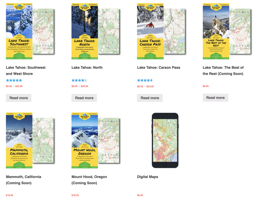
Five backcountry topographical maps to choose from:
(1) Lake Tahoe: Southwest and West Shore
(2) Lake Tahoe: North Shore
(3) Lake Tahoe: Carson Pass
(4) Lake Tahoe: the Best of The Rest of Tahoe
(5) And ..Mammoth, California
Purchase a Lake Tahoe Backcountry Ski Topographic Map and Guidebook – use snowpals21 promo discount coupon code to get 10% off your purchase for hard copy maps and digital maps for your smartphone.
Part 1
Part 2
Part 3
Part 4
Part 5
Part 6
Part 7
Backcountry Skiing, Snow-Sports Resources
✔ San Francisco Backcountry Skiers Facebook Group: ‘San Francisco Backcountry Skiers (and Riders) is a resource and inspiration for people in the San Francisco area (and beyond) who are interested in backcountry skiing and riding. SFBS welcomes both experienced and aspiring backcountry skiers and riders.’ Membership type: free, public group. 3.3k members. Visit their FB group page.
✔ SnowPals.org is a non-traditional snow-sports club for busy Bay Area professionals. Join SF Bay Area professionals to expand your circle of ski and ride buddies (resort based and backcountry), btw, that’s how we came up with our name: Snow (Snow-Sports) + Pals. Membership type: one-time paid membership fee of $20; join SnowPals. Read members’ intros to get an idea who joins. Founded in 1999 by a small group of friends; we are now 8,249 members and growing. Celebrating our 21st year of connecting folks to expand their circle of snow sports activity partners.
✔ Lake Tahoe Backcountry Ski Topographic Maps and Guidebook
✔ California Ski Company in Berkeley is one of the top ski shop retailer for ski gear for sale and rentals, plus boot fitting and equipment service. Cal Ski Co is a ‘specialty ski shop focused on ski equipment sale and rental since 1989. They sell and rent equipment for both Resort and Backcountry Ski Touring. Their team of expert ski boot fitters are the best in the business. They repair and tune about anything that slides on snow. Looking for a job? Cal Ski Co is currently hiring as of October 29, 2020. Full-time and part-time employment available: job openings, ski tech and boot-fitter. Experience is desirable but not necessary. The only criteria is that you are a skier. Interested or know of someone who is? Email resumes to .’
✔ Backcountry and Outback Adventures for Telemark and Randonee Ski Rentals, Fremont, CA and Larkspur, CA – Outback Adventures is a comprehensive outdoor adventure guide service, rental shop, and paddlesports and nordic ski specialty retailer located in the San Francisco Bay Area.
✔ Sequoia National Park Lodging WUKSACHI LODGE
Located in the Giant Forest area of Sequoia National Park, Wuksachi Lodge is a modern lodge with 102 guestrooms. It offers a cocktail lounge, a full service restaurant and both a retail and ski shop. At an elevation of 7,050 ft. (1,980 m), Wuksachi Lodge is only 4 miles away from the Giant Forest Museum.
Delaware North Parks & Resorts offers multiple services like overnight accommodations, retail, food and beverage, etc. at Kings Canyon National Park in the area of Grant Grove and Cedar Grove. Limited Internet is available in some areas of the main lodge. Wuksachi Lodge is open throughout all the seasons.
At an elevation of 6,500 ft (1,980 m), the Grant Grove Cabins is located in the Grant Grove area of Kings Canyon National Park. It offers 6 types of cabins; some are even opened all year. Main attractions like a sequoia grove, gifts shop, markets and restaurants are half a mile (800m) away from the Grant Grove Cabins. Open: All Year (limited in the winter)
✔ PEAR LAKE WINTER HUT
Managed by the Sequoia Parks Conservancy, Pear Lake Winter Hut is a rustic hut of 10 bunk beds that opens during winter and requires reservations but only for wilderness skiers who travel to Pear Lake during the cold season. At an elevation of 9,200 ft. the hut sits high above Lodgepole. This hut includes a wood-pellet stove. To get to it, you need to go through six miles on skis or snowshoes. Reservations can be made online or by phone: 559-565-3759.
Got a key backcountry resource not listed here that you’d like to share? Contact . Advance thanks for sharing.
* Browse Tahoe area rentals and private seasonal ski leases:
?
http://www.snowpals.org/rentals/
* Browse shared ski leases: :
?
http://www.snowpals.org/leases/
* How to increase bookings for your rental, ski lease listing on Airbnb, VRBO, HomeAway, FlipKey, Craigslist:
?
http://www.snowpals.org/2020/property-owners-guide-tips-create-appealing-listing-vacation-rental-ski-lease/
♥ Share this page with friends and family via , twitter, facebook.